Stickley Beaver Lodge Getaway
Call or Text: 920-680-7095
Email: [email protected]
See Main Cabin Website: www.stickleylodgegetaway.weebly.com
SLATE RIVER, PRESQUE ISLE RIVER, MARENISCO AREA:
This area is just west of the cabin. The cabin is located in a great convenient centered location to do many adventures or enjoy many destination spots.
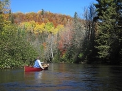
SLATE RIVER: Paddling enthusiasts flows into the head of Lake Gogebic. Paddle through gorgeous wetlands and little current. Said to be an out and back water trail. Put in at the public boat ramp in Gogebic County Park on Icehouse Bay (head of Lake Gogebic). Paddle up the Slate River. Takes you under the bridge on East Shore Road. Then, into the wetlands wilderness. Side trips up Marshall Creek and Nelson Creek. There is a pond on Nelson Creek. It is said that a good turnaround spot is where the lowlands meet up with the hardwoods. There is a shallow riffle. Be careful of Poison Ivy before this point and on your trip. There are some waterfalls on the Slate River. One is called Judson Falls. See the website at www.waterfalls-watersmeet.weebly.com for more information on the waterfalls by the cabin.
PRESQUE ISLE RIVER: It is said (from Lake Gogebic Times) that a good put in area is at the old bridge over the Presque Isle River. It is on the old Copps Mine Road. (the bridge is old, be careful of this area, use your own judgement). There is a walking path and or decline path next to the bridge to the river. And, some rocky areas in the water. The old bridge is blocked to traffic. It is said this area is a good run in the Spring or after big rainfalls. The rapids are just enough to be interesting but said not to be difficult. This water trail is said to be Class I for the first approx. 5.5 miles or so. Then, a short portage around a old logjam. Below the logjam there is approx. 8 miles of flat water with light current. Said to be pretty with mixtures of woods and siteseeing, etc. And, some Silver Maples on the banks. Yondota Falls is downstream from this put in area. It is a series of falls and very pretty. See the website at www.waterfalls-watersmeet.weebly.com for more information the waterfalls by the cabin.
Also, you could also put in at Highway M-28 and paddling upstream. If you went all the way to the logjam and back it would be approx. 16 miles. Otherwise, from the old Copps Mine Bridge down to Highway M-28 it is approx. 13.5 miles. Or, you could put in at the Highway M-28 Bridge and paddle downstream a couple miles and back, with a side trip up Mud Creek.
There are also other put in areas on the Presque Isle River. See mapbooks, information on canoeing and kayaking the area, etc. Verify information listed on mapbooks, applications, online, etc.
See our other websites on the cabin (if links do not work please print or write down to use in search or copy and paste address to search engine):
Fall: fallstickleybeaverlodgegetaway.weebly.com
Winter: winterstickleybeaverlodgegetaway.weebly.com
Cisco Chain, River History, Ontonagon River, Boat Rentals, More: www.ciscochain.weebly.com
ATV, ORV, UTV, MI-Trale, More: www.fourwheelingwatersmeet.weebly.com
For Waterfalls: www.waterfalls-watersmeet.weebly.com
Trout Fishing:
www.troutuppermichigan.weebly.com
Main Cabin Website: www.stickleylodgegetaway.weebly.com
<!-- START OF ADDME LINK --> <a href="http://www.addme.com/submission/free-submission-start.php">Search Engine Submission - AddMe</a> <!-- END OF ADDME LINK --> <a href="http://www.websquash.com">Free Web Submission</a> <a href="http://www.anoox.com/?acl_id=16413&user_id=0&landing=anoox&meta=616158"> <img src="http://www.anoox.com/images/social_net_buttons/button_A_32.jpg" border="0" width="32" height="32"> </a> <meta name="google-site-verification" content="ySb3wopRiVsz5Vc1WMKUXSeQZ-ITUoA7JzYeo3TpEWk" /> |
|
|
